What Is Photogrammetry? A Complete Guide
- Photogrammetry turns overlapping photos into accurate 3D models.
- It works with phones, drones, DSLRs, and mapping cameras.
- LiDAR is more precise; photogrammetry is cheaper and captures color.
- AI tools can shorten the traditional reconstruction workflow.
- Tripo AI turns images into export-ready 3D assets quickly.
Photogrammetry is the technique of extracting precise 3D measurements and models from two-dimensional photographs. By analyzing how the same point in a scene appears across multiple overlapping images taken from different angles, software can reconstruct depth, distance, and geometry with high accuracy.
Every time your phone creates a portrait depth map or a drone surveys a construction site, photogrammetry is doing similar work behind the scenes. From archaeology to game development, this technique turns ordinary photographs into detailed 3D models without an expensive scanner. In this guide, you will learn how photogrammetry works, its main types, what hardware and software you need, where it is used, and how AI tools are making the process faster.
What Is Photogrammetry?
The word “photogrammetry” comes from Greek roots: photo means light, gramme means drawing or record, and metron means measure. In simple terms, photogrammetry means measuring with light. The name sounds technical, but the basic idea is easy to understand: if you photograph the same object from enough angles, software can estimate where its surfaces sit in 3D space.
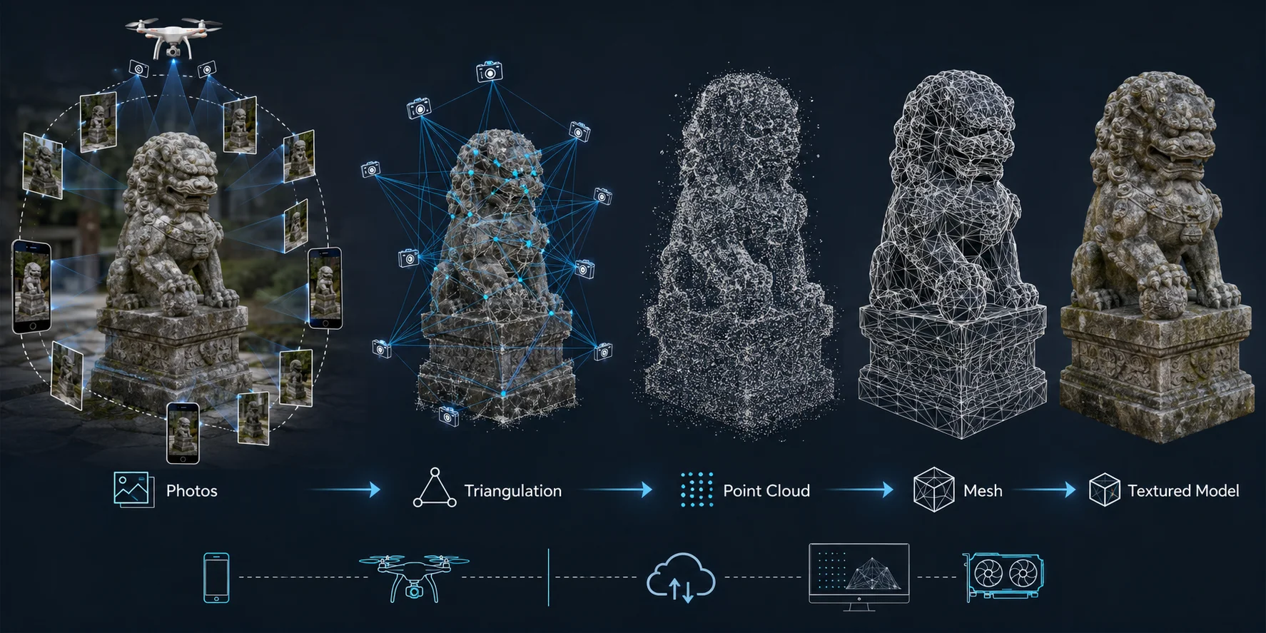
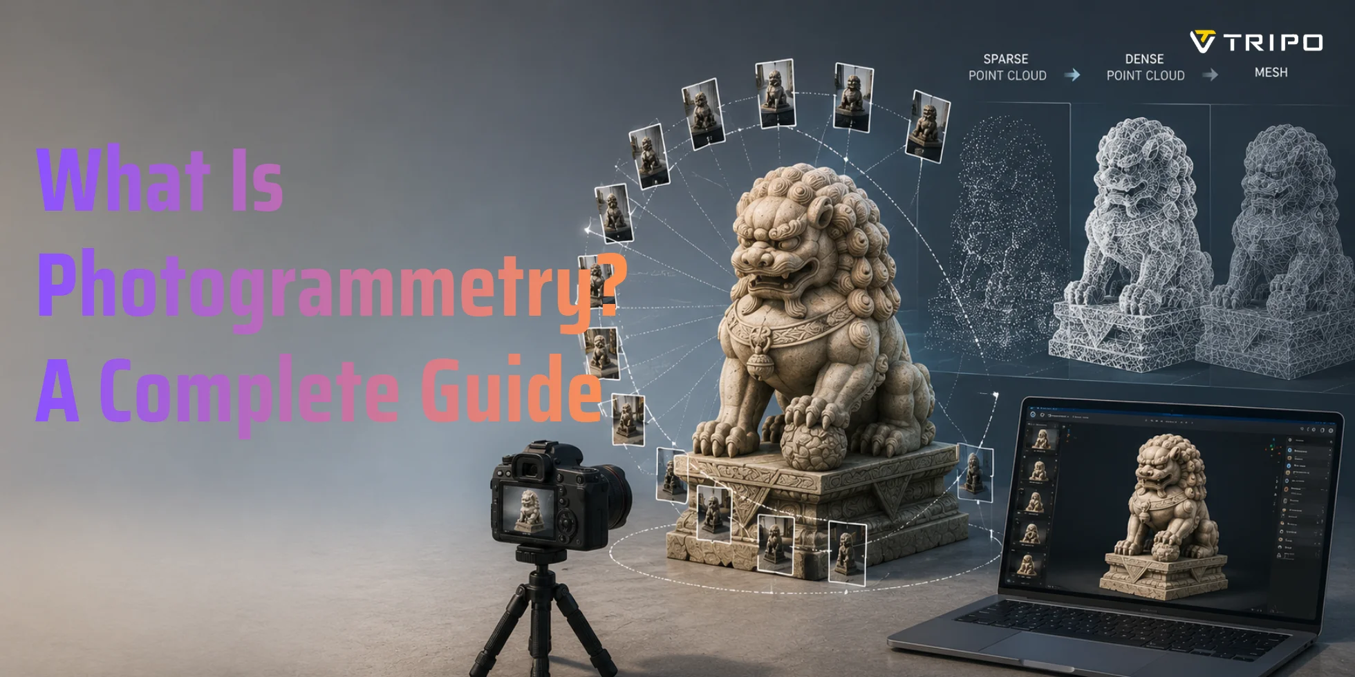
The core principle is triangulation. When the same corner, edge, scratch, brick, or texture detail appears in several images, the software treats it as a shared feature point. It matches that point across photos, compares the camera positions, and calculates the point’s 3D location. Thousands or millions of these points form a point cloud.
From there, the point cloud can be converted into a polygon mesh. The original photos are then projected back onto that mesh as texture maps, giving the final model realistic color and surface detail.
Photogrammetry is not new. It predates digital cameras by more than a century and was used early in aerial mapping and surveying. What has changed is access. Today, a smartphone, drone, GPU, and cloud software can make photogrammetry useful for creators, engineers, researchers, and hobbyists.
How Does Photogrammetry Work?
Photogrammetry follows a repeatable pipeline. The details vary by software, but most workflows move through five main stages.
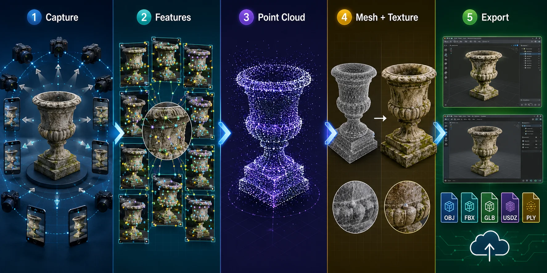
Step 1 — Capture. Photograph the subject from many angles. For most objects and scenes, each image should overlap the next by at least 60-80%. Sharp focus, consistent lighting, and steady exposure are critical. A blurry image or a sudden lighting change can prevent the software from matching shared features.
Step 2 — Feature detection. The software looks for keypoints, such as corners, edges, small texture changes, or high-contrast patterns. These features are easier to match than smooth, blank surfaces. Algorithms such as SIFT or ORB are often used to detect and compare these visual details across photos.
Step 3 — Point cloud generation. Once the software knows where matching points appear in multiple images, it triangulates their X, Y, and Z positions. This creates a sparse point cloud first, then often a denser point cloud after more refinement. The denser the cloud, the more information the software has for building geometry.
Step 4 — Mesh and texture. The point cloud is converted into a polygon mesh. The mesh may need cleanup because holes, floating fragments, or noisy geometry can appear. Then the software projects the original photographs onto the mesh to create texture maps.
Step 5 — Export. The finished model is exported as OBJ, FBX, GLB, or another 3D format. From there, you can use it in Blender, Maya, Unreal Engine, Unity, CAD tools, web viewers, or 3D asset pipelines.
Three Types of Photogrammetry
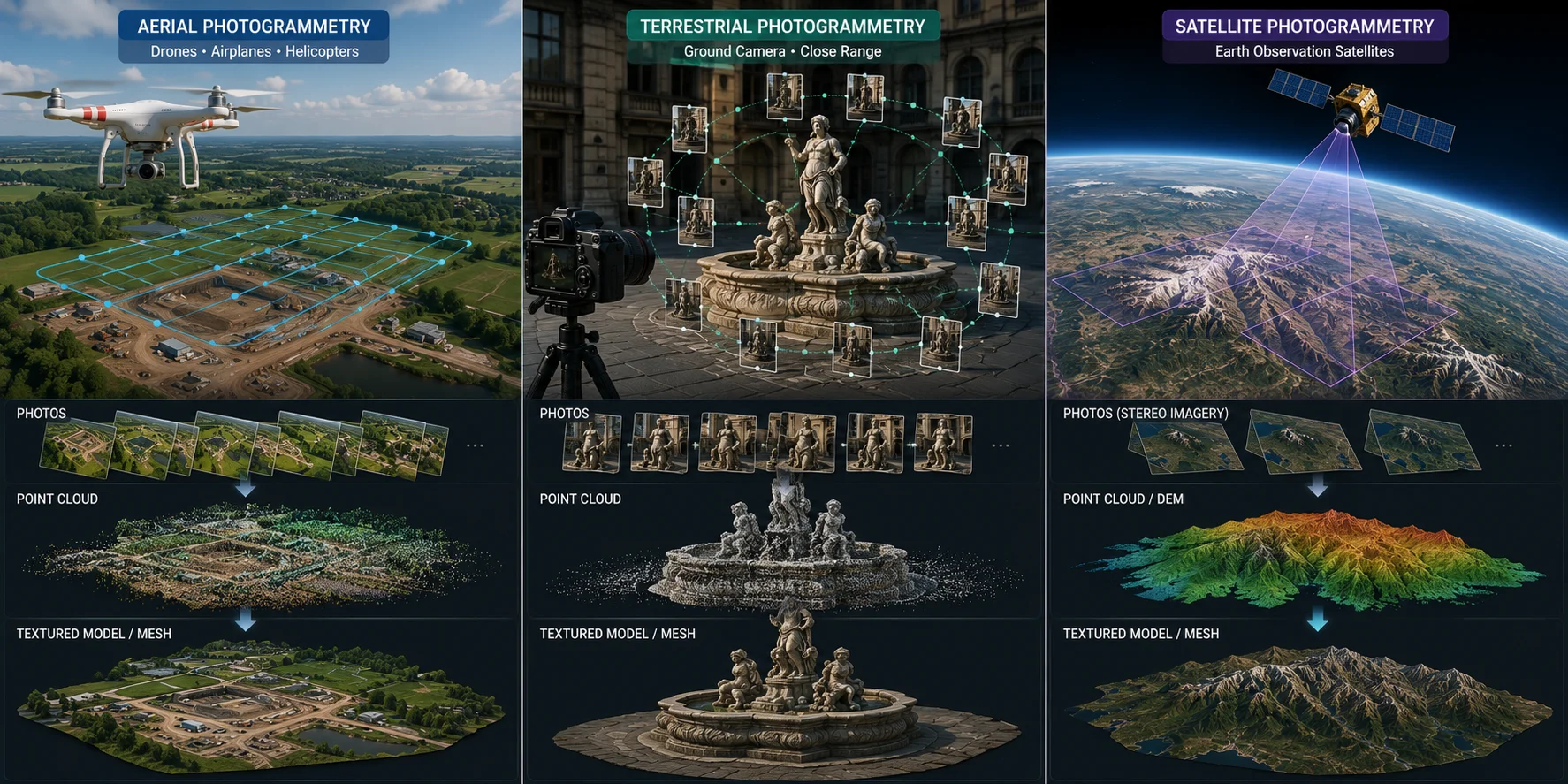
Aerial photogrammetry uses cameras mounted on drones, airplanes, or helicopters. It captures large areas from above and is common in topographic mapping, construction monitoring, city planning, precision agriculture, and mining. Drone-based aerial photogrammetry has made this method more accessible because small teams can now scan fields, roofs, roads, or job sites without hiring aircraft.
Terrestrial photogrammetry, also called close-range photogrammetry, uses a camera on the ground. A photographer circles a subject such as a statue, building facade, vehicle, prop, machine part, or artifact while capturing overlapping images. This is the most common approach for game asset creation, VFX, museums, product capture, and cultural heritage preservation.
Satellite photogrammetry uses stereo imagery from Earth observation satellites. It is used to create elevation models, large-scale terrain maps, and environmental datasets. It is less relevant for hobbyist 3D asset creation, but it is important in geology, defense, climate research, disaster response, and national mapping programs.
The three types share the same core logic: use multiple views to infer 3D structure. The difference is scale, camera platform, and accuracy requirement.
Photogrammetry vs. 3D Scanning: Which Is Better?
Photogrammetry and 3D scanning both produce digital 3D representations, but they collect data differently. Photogrammetry uses ordinary photos and visible light. Structured-light or laser scanners project a known pattern or beam onto a surface, then measure how that pattern changes to calculate geometry directly.
Photogrammetry is usually cheaper. A smartphone, DSLR, or drone camera may be enough to start. It also scales well. You can capture a small sculpture, a room, a building, or a landscape using the same principle. Because the input is photography, photogrammetry captures rich color and texture naturally.
3D scanning is stronger when you need controlled geometric precision. It can perform better on reflective, transparent, textureless, or uniformly colored surfaces that confuse image matching. It is often preferred for engineering inspection, dental workflows, medical devices, and industrial parts where measurement tolerance matters.
For creators, the choice depends on the goal. If you need a realistic rock, statue, room, prop, or outdoor site, photogrammetry often gives excellent results at a lower cost. If you need sub-millimeter precision or a difficult surface, a scanner may be better.
Many professional workflows combine both methods. Use photogrammetry for large textured areas and 3D scanning for challenging details.
Photogrammetry vs. LiDAR
LiDAR stands for Light Detection and Ranging. It fires laser pulses and measures how long they take to return. This creates an accurate point cloud without relying on visible texture. LiDAR can work in low light or darkness, and some systems can capture terrain under vegetation better than camera-only methods.
Photogrammetry relies on visible-light images and texture contrast. It struggles with blank walls, shiny surfaces, water, glass, smoke, and poor lighting. If the camera cannot see enough distinct features, the software cannot match points reliably.
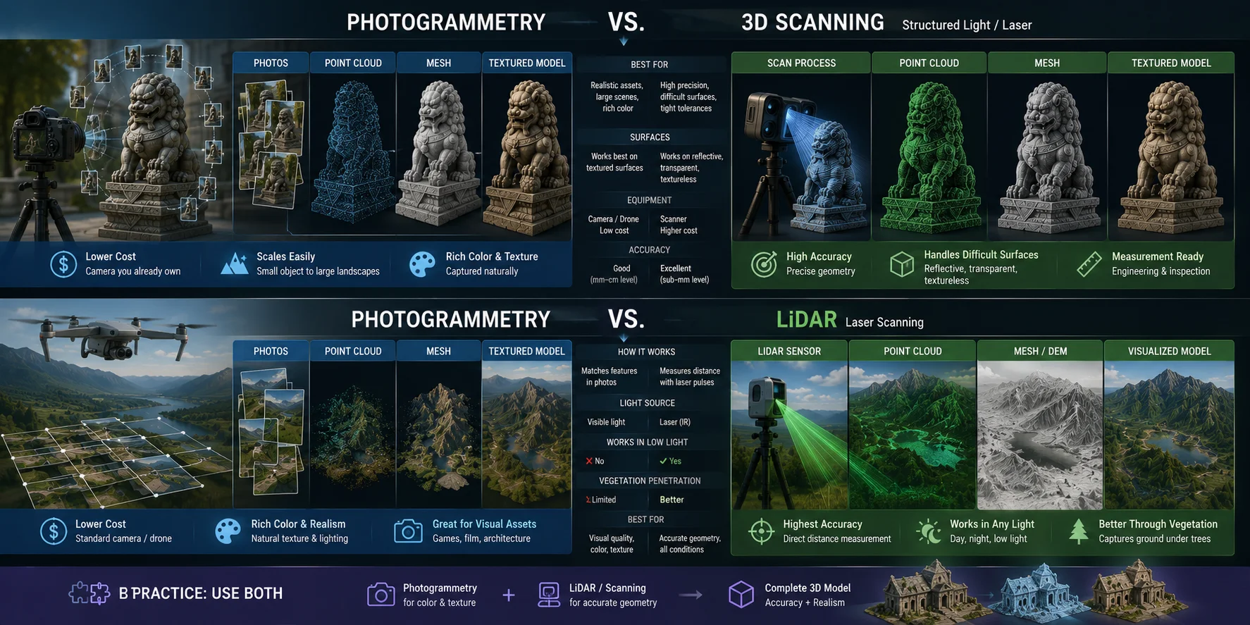
Where photogrammetry wins is cost and color. A drone with a standard camera is usually much cheaper than a LiDAR-equipped mapping system. Photos also provide natural texture and color, which is important for game assets, film sets, architecture visualization, and cultural heritage models.
LiDAR wins when geometry accuracy matters most. Surveying, autonomous vehicles, robotics, forestry, and infrastructure inspection often benefit from LiDAR because it provides direct distance measurement.
The best professional approach is often sensor fusion. LiDAR supplies reliable geometry, while photogrammetry supplies color, texture, and visual realism.
Can You Do Photogrammetry with a Drone?
Yes. Drones are one of the most popular tools for photogrammetry, especially for outdoor surveys, construction progress tracking, mapping, agriculture, and terrain capture. They can cover areas that would be slow, unsafe, or impossible to photograph on foot.
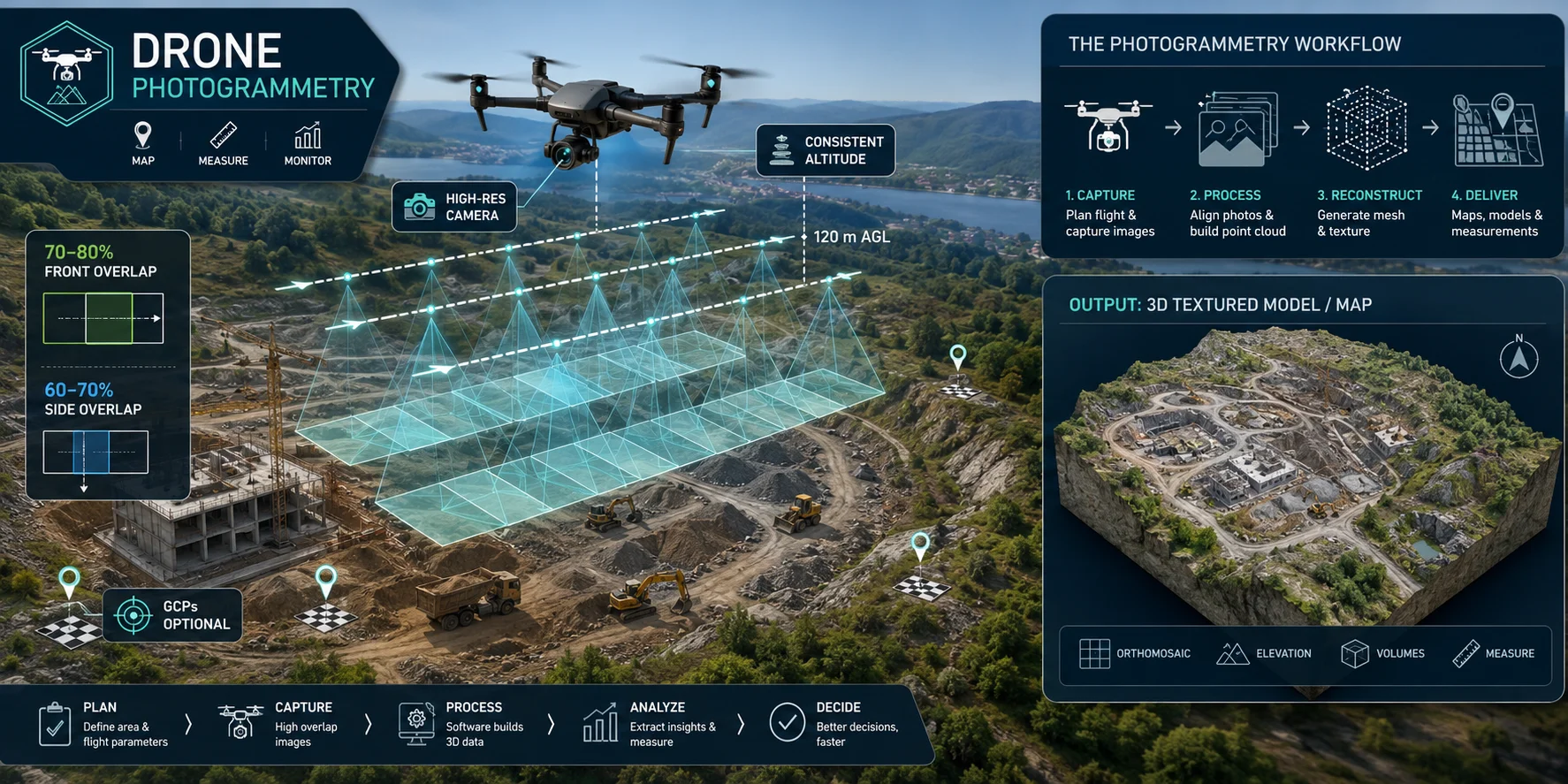
For best results, fly at a consistent altitude and maintain strong overlap between photos. A common target is 70–80% front overlap and 60–70% side overlap. For complex terrain, forests, construction sites, or high-accuracy surveys, more overlap is often better. Most drone mapping apps can automate flight lines, camera spacing, and image capture.
Camera quality matters. A high-resolution camera with sharp focus and stable exposure improves reconstruction quality. A mechanical shutter can reduce motion distortion during flight, especially when the drone is moving quickly. Avoid strong shadows, reflective roofs, moving vehicles, and wind-blown vegetation when possible.
Ground control points, or GCPs, are physical markers with known GPS coordinates. They improve absolute accuracy when the final model must match real-world coordinates. For engineering, legal, or survey-grade work, GCPs can be essential. For games, VFX, and visual assets, they are usually optional because visual quality matters more than survey precision.
Photogrammetry Software and Hardware
You do not need exotic hardware to start. A smartphone can work for simple objects. A mirrorless or DSLR camera gives more control over focus, exposure, and lens quality. A tripod helps when shooting indoors, a turntable helps for small objects, and a drone is the best tool for large outdoor subjects.
Traditional photogrammetry software handles feature detection, image matching, camera alignment, dense point cloud generation, mesh construction, and texture projection. This process can be computationally heavy. Large scenes may take hours to process, while GPU acceleration and cloud systems can reduce wait times.
Mobile apps and cloud tools now make photogrammetry easier, but capture quality still matters. Use even lighting, avoid motion blur, photograph every side, and make sure the subject fills the frame. Objects with glossy, transparent, or plain surfaces may need powder spray, markers, or better lighting.
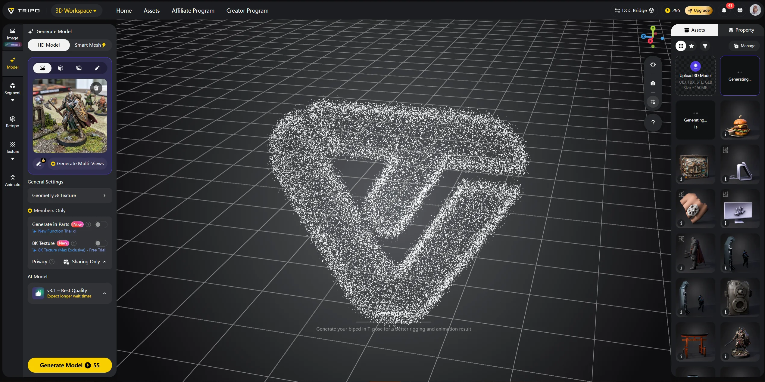
AI tools are changing this part of the workflow. Tripo AI’s Image-to-3D and Multi-view-to-3D workflows take photogrammetry’s core idea — inferring 3D from 2D images — and compress it into a faster, AI-native process. Instead of manually managing dozens of images, point clouds, cleanup steps, and export settings, you can upload one or more references and receive a textured, export-ready model.
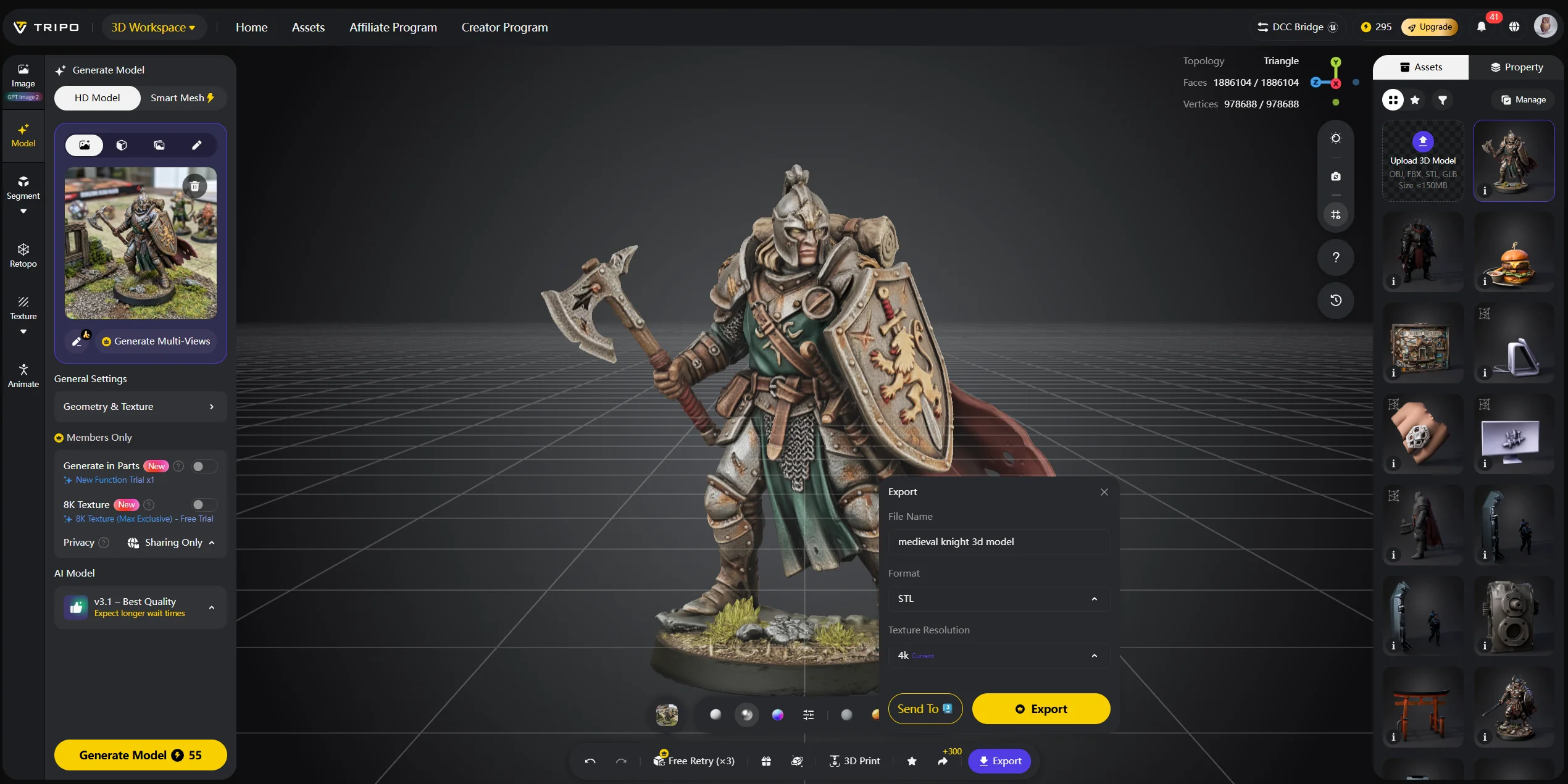
For digital asset creation, this is especially useful. You may not need survey-grade accuracy; you may need a prop, creature, product mockup, miniature, or game object quickly. In that case, AI-assisted reconstruction can be a faster route into production.
Photogrammetry Applications
Gaming and VFX. Game studios use photogrammetry to scan rocks, trees, buildings, streets, props, and real-world locations. The technique helps artists create realistic assets at scale. Film teams also scan actors, costumes, props, and sets for visual effects.
Architecture and construction. Drone photogrammetry creates as-built models, tracks construction progress, measures stockpiles, and documents sites before renovation. It helps teams compare real site conditions against plans.
Cultural heritage and archaeology. Museums and research teams digitize fragile artifacts, ruins, cave paintings, statues, and excavation sites. A 3D model can preserve an object, support remote study, and reduce physical handling.
Dental and medical workflows. Intraoral photogrammetry can measure tooth and jaw geometry for implant planning, prosthetics, and orthodontic workflows. In these fields, accuracy and repeatability matter more than visual beauty.
Forensics and accident reconstruction. Investigators can use photos to document crash sites, crime scenes, footprints, vehicle damage, and physical evidence with measurable geometry.
Agriculture and environmental monitoring. Drone photogrammetry helps monitor crop conditions, erosion, deforestation, coastal change, landslides, and landform movement over time.
Frequently Asked Questions
What is photogrammetry?
Photogrammetry is the process of measuring and reconstructing 3D geometry from 2D photographs. It works by matching overlapping image features and calculating their position in 3D space.
What are the three types of photogrammetry?
The three main types are aerial, terrestrial, and satellite photogrammetry. Aerial uses drones or aircraft, terrestrial uses ground-based cameras, and satellite photogrammetry uses orbital imagery.
Is photogrammetry better than 3D scanning?
It depends on the use case. Photogrammetry is cheaper, scales well, and captures color naturally. 3D scanning is often more precise on reflective, transparent, or textureless surfaces.
Which is better, LiDAR or photogrammetry?
LiDAR is better for high-accuracy geometry, low-light capture, and vegetation penetration. Photogrammetry is cheaper and captures color texture automatically. Many professional workflows combine both.
Can I do photogrammetry with a drone?
Yes. Drones are ideal for aerial photogrammetry because they capture many overlapping images quickly. Use automated flight planning and high overlap for reliable results.
What camera do I need for photogrammetry?
Any sharp camera can work, from a smartphone to a DSLR. Consistent exposure, focus, lighting, and overlap usually matter more than sensor size.
What software is used for photogrammetry?
Traditional photogrammetry software turns images into point clouds, meshes, and texture maps. AI platforms like Tripo AI can also reconstruct 3D models from images in a faster, generation-first workflow.
What is photogrammetry used for in dentistry?
Dental photogrammetry measures tooth and jaw geometry for prosthetics, implant planning, and orthodontic workflows. It is used when precise spatial relationships matter.
How many photos do I need for photogrammetry?
It depends on the object. Small objects often need 50–100 photos, while buildings or drone surveys may need far more. The key rule is maintaining strong overlap.
How is AI changing photogrammetry?
AI models can infer 3D geometry from one or a few photos, reducing the need for a long manual capture pipeline. Tools like Tripo AI’s Image-to-3D represent this faster, AI-native direction.
Conclusion
Photogrammetry has evolved from a surveying technique into a core tool for creators, engineers, drone pilots, and researchers. Whether you are capturing a construction site from the air or scanning a prop for a game, the fundamentals remain the same: take overlapping photos, let software find matching features, and turn the result into a 3D model.
Traditional photogrammetry remains powerful when you need measurement accuracy, full-scene reconstruction, or mapping-grade outputs. But if your goal is digital asset creation, you may not need the full manual pipeline every time.
If you want to skip much of the capture and processing work, Tripo AI Studio lets you go from image to export-ready 3D model quickly, without a traditional photogrammetry setup. Explore Tripo AI Pricing to find the right tier for your workflow.